
 CANCELLED
Under
Development, check back for updates, last update: May 14, 2008
Due to current health and other
personal issues, this ride will not go forward as planned.
Feel free to try some of the trails. Some trails are dedicated
riding or multi-use trails, some are logging or remote resource roads,
some connecting trails are unproven. Some trails have been lost
due
to industrialization or reclassification of the area, some have been
turned into hiking only or privatized ... but most are still available.
I will continue to evaluate the possibility of doing
this ride and repost if it becomes possible.
Wayne Delbeke, May 14, 2008

 The GREAT
DIVIDE RIDE
The GREAT
DIVIDE RIDE 

July/August
2010 (Tentative see "When" below)
The
'Actual
Date' will depend on People, the Mexi-Can ride and Other issues For
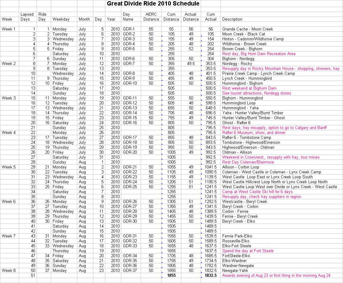
tentative dates and ride distances, see Schedule
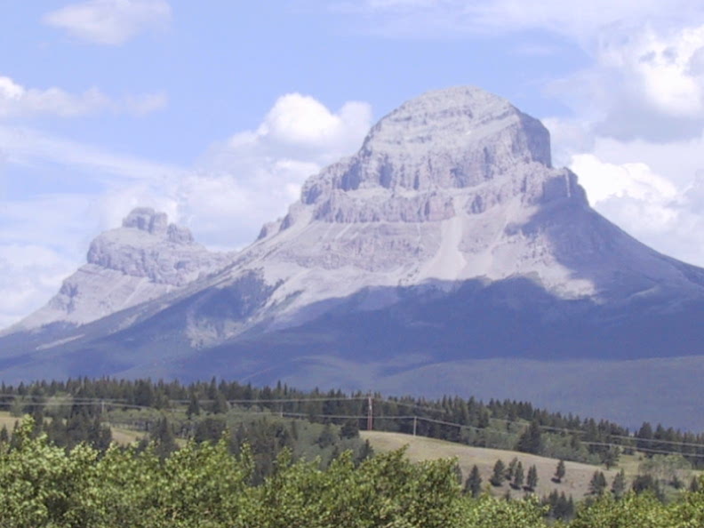
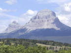 The "Sentinel" at the entrance to the Crowsnest pass through the Great
Divide. Click to view. Ride Map-->
The "Sentinel" at the entrance to the Crowsnest pass through the Great
Divide. Click to view. Ride Map--> 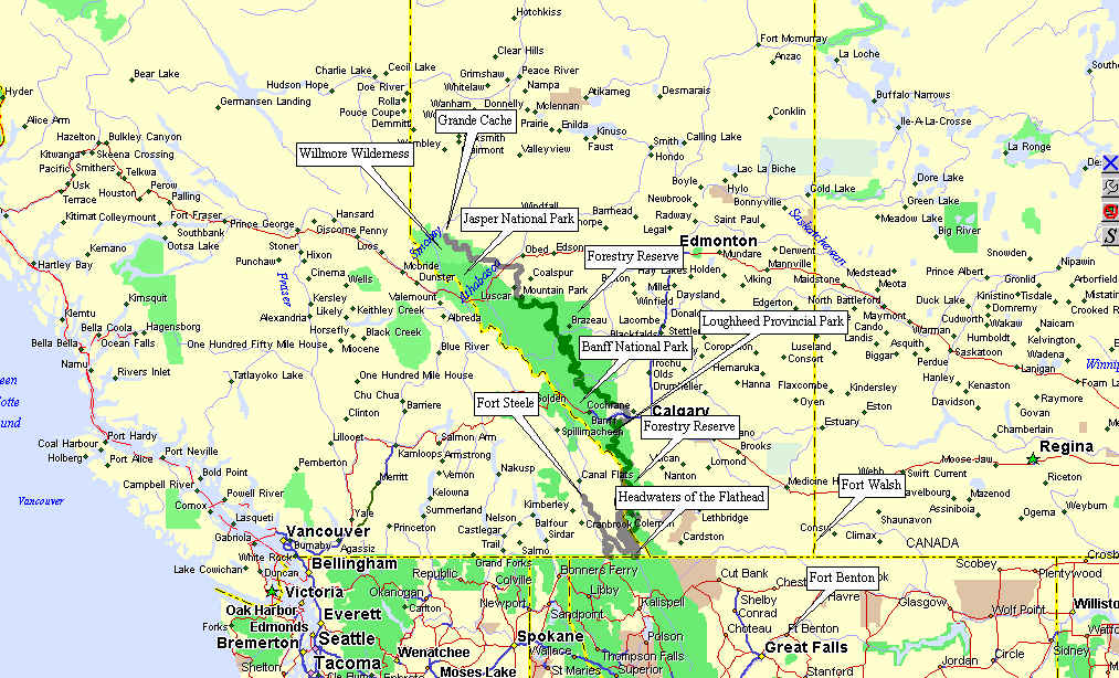
Google Earth Map of possible route: Canadian Great Divide
Ride
If you need a free Google Earth Viewer , go to: http://www.earth.google.com
Why:
Once upon a time there were the Pony Express rides of 2001 and 2004
put on by the Duck and supported by the Nicholson Family - Dave, Annie,
Calina, grown sons and their friends. See http://www.XPRides.com.
At the end of the 2004 XP ride after crossing 1250 miles from Nevada
to the Rush Creek Ranch in Nebraska, a lot of the riders would have
liked
to have kept on riding. It was a great time. But it was
evident
that the historical Pony Express Trail was going to be much more
difficult
to ever do again due to roads, fences, lack of access to the trail,
bureaucracy
and other reasons. Minds began to think of a new adventure. For a
while during the Pony Express Ride, we camped out on the Great Divide
in
Wyoming and rode the Great Divide Trail. People began to think
about
a north south ride in the western wilderness - the Pacific Crest Trail,
the Great Divide, perhaps a historical trail like the Chisholm Trail.
The Duck puts on great rides but he said he needed some recovery
time,
maybe in 4 years. It is now possible that there will be an XP
Duck
ride in 2008. However it will likely start at the Mexican
border and have to be done in at least three sections as the total
length
of trail from Mexico to Canada is about 3000 miles.
In the meantime, we riders in the Great White North have never had a
long distance Pioneer Ride. So, after all the discussion at Rush
Creek, I came home and bought some maps and some software in order to
look
at the possibility of a ride along the Cowboy Trail or west in the
foothills
and Rockies along the forestry roads, park trails, and the Great Divide
Trails that are supported by the outfitters, sport horsemen, and
recreational
activities that have preserved the Canadian trails in the
wilderness.
Based on the mapping and trails that I know about, the biggest problem
on this route is not trails but access for crews. There are many
back country trails that are available by horseback but not to vehicles
every 25 miles or so. But after a few weeks of planning,
routes,
and alternate routes with vet checks and crew access has been
identified
from the Willmore Wilderness south of Grande Cache to the US Border at
the head waters of the Flathead River east of Cranbrook. The
length
of trail selected is around 1500 miles.
As of June 2005, we have looked at over 2500 miles of trails, ridden
or driven over 1000 miles of them to check on campsites and lunch
stops.
We are presently debating whether to do a single 1500 mile ride or two
750 mile rides and what year. August still appears to be the best
month because of forest access issues, least conflict with other rides,
weather in the Rockies, least flood and wild animal conflicts.
When
(After the Mexi-Can?):
It now appears the Duck and/or friends of the Duck will be
organizing
the Mexi-Can ride for 200_???????????.
As people need to plan and commit for
a long multi-day months if not years ahead, it would be prudent to make
the Canadian Great Divide Ride (GDR) two years after the
Mexi-Can.
This gives the long riders a year off between major commitments of
time,
money, and horse flesh. If the Mexi-Can is slated for 2008, then
the
GDR will be in July/August 2010. We were considering one
1500 mile, 6 week long ride or breaking it into two 750 mile 3 week
rides.
However, in reviewing trails, we are now up to about 1850 to 1900 miles
over 37 riding days. We are considering doing some 5 day trial
sections of the ride so that some of the proposed trails will have been
tested
out, ridden and revised as necessary before the long ride
commitment.
This will depend on many factors including commitment of veterinarians,
riders, volunteers, trail availability, approvals and so on.
Where:
The map at the top of this page gives a general indication of the
ride
route but is not specific at this time. A tentative route
: Canadian
Great Divide Ride
This ride is almost entirely in remote areas managed by Alberta
Sustainable
Development and very little near private land. Individual week by
week,
day by day maps will be posted along with trail descriptions as the
trails
are ridden, measured, described and GPS way points produced.
The ride will be mostly along the eastern slopes of the Rocky
Mountains
on Provincial Crown Land. Camping will be in remote unserviced
areas,
frequently in Government sponsored multi-use camps for horses, off
highway
vehicles, hikers, fisherpeople, and nature lovers. People are
generally
used to multi-use camping and horses so the potential for conflict is
minimal.
Most developed Government horse camps have manure and straw disposal
areas,
the remote camps will require spreading of manure and minimal impact
camping.
Brochure information from the Government will be posted at the ride but
will generall be in accordance with the Random Camping User's Guide
at http://www.srd.gov.ab.ca/lands/usingpublicland/recreation/pdf/07_Random_Camping_Final.pdf
. Weed free hay should be used where available in remote areas to
prevent spread of weeds in the backcountry. Hay re-supply will be
investigated from local suppliers near Rocky Mountain House - we have a
supplier of Orchard Grass/Alfalfa mix that is weed free for the second
and third weeks (not certified, certification not a requirement at this
time) Export quality compressed hay - Timothy and Alfalfa and mixes -
may
be available. If there is enough demand, the ride will arrange
transport
or access for the Rocky Mountain House section of the ride. Other
sections will be reviewed in time. June 25, 2005
Each week has been planned to allow people to fuel up and obtain
supplies
in a reasonably good sized town. Day 2 we will pass through
Hinton,
after Day 7 we will rest one day in Rocky Mountain House, Day 15 ends a
few miles west of Cochrane and about 45 miles from Calgary. Day
20
ends just north of the regional community of Crowsnest
pass.
Day 25 will be end up in the same region after multiple crossings of
the
Great Divide in Flathead Country. Day 30 will end in the
Cranbrook/Fernie,
British Columbia area with multiple options for fuel, groceries and
supplies
and departure points.
Detailed Trail descriptions and maps will be added as they are
developed.
Go to Trail descriptions at the bottom of this page for more
information.
NOTE: Final trails selection will/may be adjusted, even during
the ride as trails and various areas are subject to sudden closure due
to presence of bears, cougars, or migrating ungulates and other
wildlife,
fire suppression, and changes due to trail use or overuse to preserve
them
and protect the public. Trails that are open for hiking are
sometimes
closed to equestrian and off highway vehicle (OHV) users during periods
of susceptibility. Flexibility in selection of trails is a requirement
in the backcountry.
Who:
Those who are first to commit and can meet the "Duck Like" criteria
for membership in the Great Divide Ride Group (GDRG). All GDRG
riders
will have to be members of the Endurance Riders of Alberta (ERA) for
insurance
purposes. Non ERA members will pay an additional fee to join the
GDRG and will have to fill out an ERA membership form. The GDRG
reserves
the right to restrict membership due to the limited availability of
camping
sites for this ride and for any other reason whatsoever at the
discretion
of the Board of the GDRG.
Membership criteria and costs will be added to the site in
time.
In the meantime, go to http://www.XPRides.com.
to see what membership requirements are likely to be modelled after.
THINGS
YOU SHOULD KNOW:
This ride will be on the eastern slopes of the Rocky Mountains/Great
Divide. Weather changes can be severe. It can go from 30
degrees
Celsius (90 degrees F) to below freezing in less than an hour.
Weather
can be clear and sunny and change to rain, hail or snow in a few
minutes.
Dress and carry gear accordingly.
Most of the trail will be in wilderness areas. You should
consider
carrying a survival kit (first aid, knife, whistle, reflective blanket
etc.) and emergency rations. The reflective blankets are
excellent
for keeping injured people warm and make a good marker for a landing
area
in the case of the need for a helicopter rescue.
Front runners should consider carrying a small folding saw to cut
dead
fall off the trail that cannot be easily bypassed.
In a lot of the back country area cell coverage is sporadic but
often
available at high points. Most of the area is covered by 911
calls
and Stars Air Ambulance services in case of emergency. Out
of province or out of country visitors should be sure to have
appropriate
medical insurance coverage.
Be "Bear Aware". See http://www.srd.gov.ab.ca/fishwildlife/livingwith/bearfacts/bearsmart.aspx
Cougar Guidelines: http://www.srd.gov.ab.ca/fishwildlife/wildlifeinalberta/cougar/default.aspx
Camping rules for wilderness camping in Alberta are located
at: http://www.srd.gov.ab.ca/lands/usingpublicland/recreation/pdf/07_Random_Camping_Final.pdf
OR: GreatDivideRide/07_Random_Camping_Final.pdf
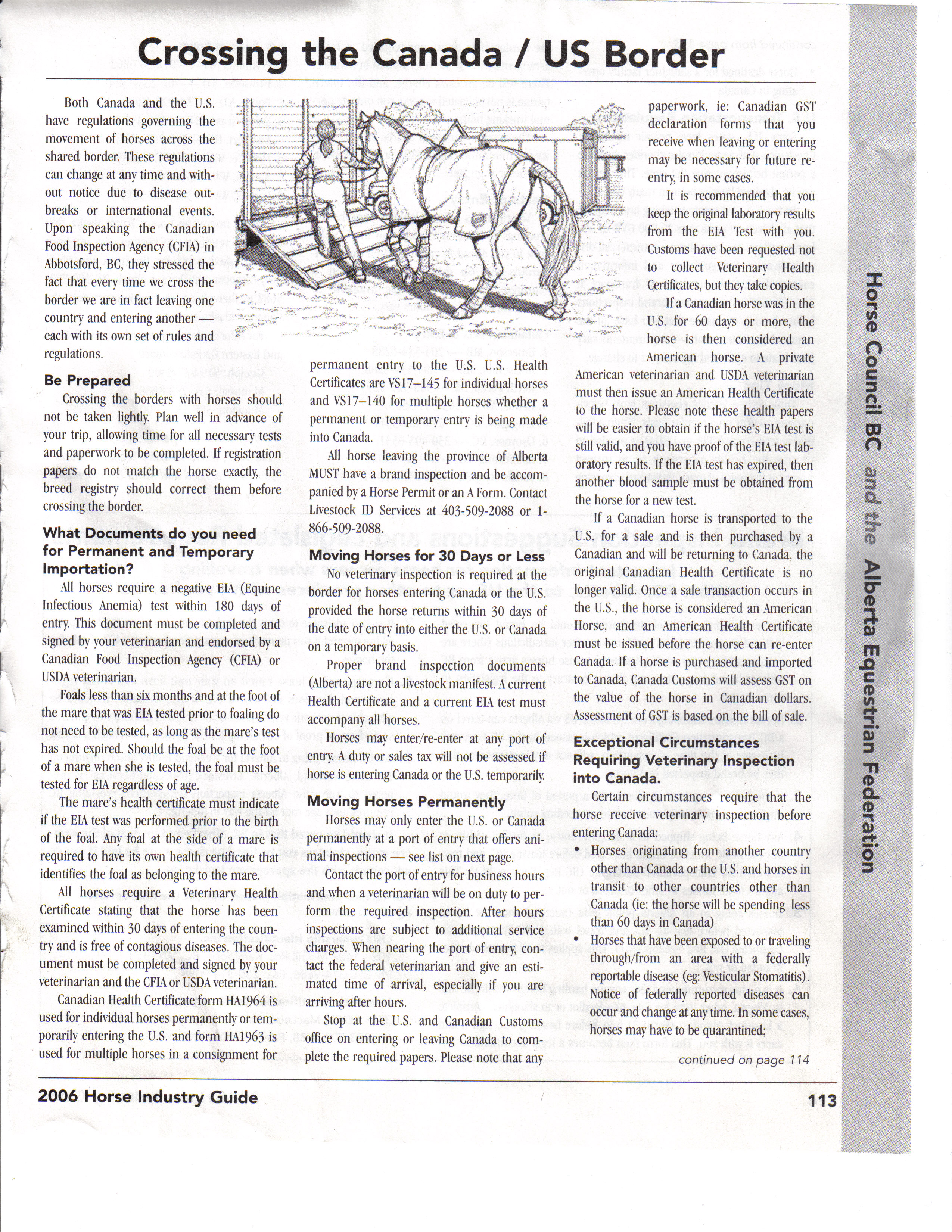
Crossing the US/Canada border: GreatDivideRide/BorderCrossing_1.jpg
GreatDivideRide/BorderCrossing_2.jpg
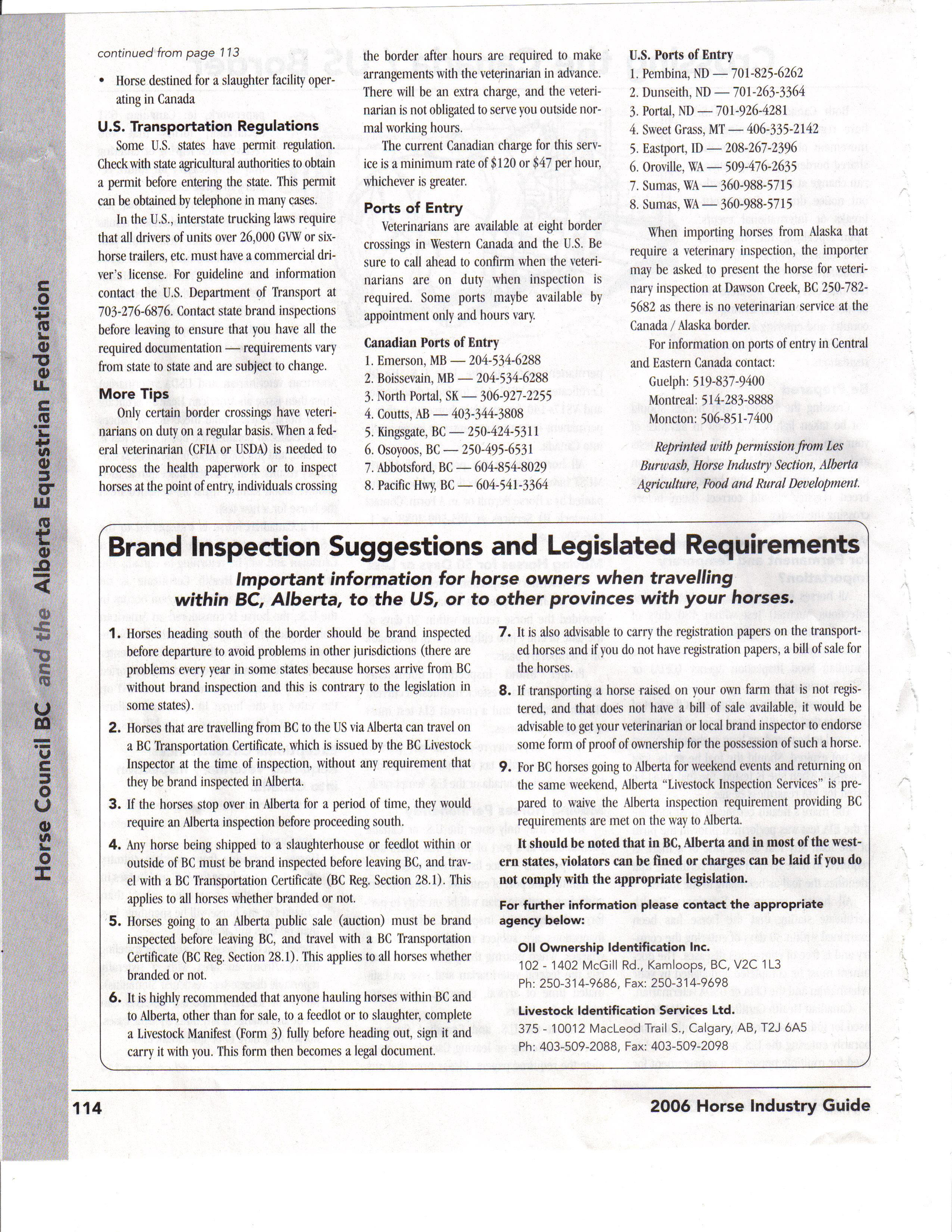
Brand Inspections: GreatDivideRide/AlbertaBrandInspection.jpg
Carry your registration papers, transport papers and proof of ownership
with you. In absence of a brand inspection, proper waybills or
MANIFESTS must be filled out to move horses more than a few
miles. The ride will provide a Manifest book to each rider at the
start of the ride. Manifest booklets are free at government
offices. Each rider/owner will be responsible for filling out the
appropriate manifests.
We will also try to arrange for brand inspections of all the horses
at the begining of the ride at an appropriate location and date that
works for the brand inspectors.
More to come, last revised: November 26, 2007
Trail
Descriptions: (Newer trail concept per google map
may not exactly match descriptions below, some new trails are a bit
longer. New descriptions will be provided as trails are ridden
and proofed.)
See
Summary of ride at the end of this section - dates and distances - Schedule
Key to trail
status: P = Preliminary;
PV05 = Partly verified+year, 04 means 2004 or before and will have to
be
checked for passability before finalizing even if fully verified,
partly
verified means there may be sections of the trail that need to be
reviewed
or were unaccessable to date; FV04 = Fully Verified + year,
fully verified means the whole trail has been ridden or driven, but if
2004 or before it will need reverification; MD = Mapped and
Detailed ie. trail has been measured by vehicle or with GPS with
waypoints,
distances and trail description prepared for maps and direction for ride
Week one (Start
Date tentatively Monday, July 5, 2010):
Day one - Start south east of Grande Cache on
Cowlick/Mountain
Trail from staging area between Grande Cache and Victor Lakes to A la
Peche
Lake following the A La Peche Trail to the Muskeg River Lunch stop,
then
take Mahon Creek Trail to Adams Creek Trail (Two routes available) to
Berlund
Creek Camp. Remote area, distance may have to be 55 miles to get
from trail head to trail head. Lunch at 27 miles.
Location map, local trail and local history available at: http://www.grandecache.ca
PV05
Day Two - Possible Pinkerton start to reduce
miles,
jump out at Little Berland River and take either the the Collie Creek
or
Mumm Creek trails to the Wildhay River for lunch, then the Ice
Water/Solomon
Creek Trail to the Black Cat Ranch Camp. Collie Creek route from Camp
is
48+ miles. Pinkerton start and Mumm Creek Trail approx 50 miles.
Lunch at 30 miles. Black Cat Ranch: http://www.blackcatguestranch.ca/
PV05
Day 3 - Trailer across the Athabasca River from
the
Black Cat Ranch through Hinton (Gas and Grocery stop) to Highway 40 and
junction of Township Road 253b - ride Township, Forestry roads and two
track over hill and dale to reintersect with Highway 40 north west of
Cadomin,
follow highway and mining road through Cadomin to Provincial Horse Camp
south of Cadomin (Corrals available). Lunch at 29 miles.
Hinton
Information: http://www.town.hinton.ab.ca
Many of the places we will pass through are
listed
in http://ghosttowns.com Cadomin: http://www.ghosttowns.com/canada/alberta/cadomin.html
FV05
Day 4 - Ride out of Provincial Horse Camp below
mining
road to Mountain Park, turn left through campground then right onto
Cheviot
trail to Cadomin_Chunga Creek Road, follow forestry road along Cardinal
River to Ruby Creek (alternate trails via Muskiki Lake or Flapjack Lake
depending on weather), then along Brazeau River to Chunga Creek Trail
Camp
near or at confluence of the Cardinal and Brazeau Rivers or trailer to
Brown Creek Camp. Brown Creek to Big Horn Camp is 53 miles, Chunga
Creek
to Big Horn Camp is 60+ miles so probably do a Pinkerton Start from
Brown
Creek or Camp at Brown Creek depending on availability of Camp sites.
Trail
50 miles. Lunch 30 miles, Muskiki Creek.
FV05
From Day 4 to Day 13, we will
be riding in the Big Horn Wilderness area
in the County of Clearwater.
For information about this area see: Big Horn Wilderness Area: http://www.srd.gov.ab.ca/fieldoffices/clearwater/bighornbackcountry/default.aspx
Clearwater County including Rocky Mountain House and Nordegg
information:
http://www.rockymtnhouse.com
Day 5 - Follow Chunga Creek Trail to Brown Creek
Trail or start at Brown Creek Camp and take Chunga Creek trail into
back
country, take high country four track to confluence of Wapiabi Creek
and
Blackstone River, then Lookout Creek Road to Sturrock Creek Road
(dirt/gravel
4WD roads, good crew access from south for Lunch), Sturrock Creek Road
to Sturrock Creek Horse Camp, Lunch, turn off road to follow
Wapiabi
Creek trail through Wapiabi Gap to Sunkay Creek Trail, down improved
trail
to Crescent Falls Picnic Site, cross the Big Horn River, follow
mountain
trail to Tershishner Creek trail to Abraham Lake and Big Horn Dam
Provincial
Horse Camping Area for the Weekend. Trail length 50 to 55 miles
depending
on weather and trail access. Lunch at trail head, 30 miles.
FV05
Minor shopping, fuel and showers at Nordegg, Thompson Resort, and
Big
Horn Indian Reserve store.
Columbia Ice Fields tours, Helicopter tours and other touristy things
available in Jasper/Banff National Parks and the Thompson Resort area
next
to the Big Horn Dam and the Cline River Area, mine tours and spelunking
available at Nordegg. Several rock climbing and preserved natural
areas are available for those interested. Links to interesting
sites
will be posted at a later date (June 25, 2005).
Nordegg Historical Society: http://www.nordegghistoricalsociety.8m.com
Caving, Hiking, Helicopter tours: http://www.icefieldheli.com
or http://www.nordeggheli.com
Columbia Icefields Tours: http://www.explorejasper.com/sights/columbiaicefield.htm
Jasper National Park: http://www.pc.gc.ca/pn-np/ab/jasper/index_e.asp
Kootenay Plains and Siffleur Wilderness Areas: http://www.whereadventurebegins.com/scenicfalls.htm
One day rest on long ride, second day of rest in two days in Rocky
Mountain
House, larger town to resupply. We will return for a two day rest
at this site in one week.
Week Two:
The week two area is covered by the Big Horn Management Area
reference
above.
Day 6 - Start from Big Horn Camp and do
loop
along Abraham Lake and back along the base of the mountains for 29
miles
to lunch back in Camp. After lunch, back track day 5 trail to Crescent
Falls Picnic site, follow access road back to Highway 11, follow quad
trails
to Nordegg camp ground either in Nordegg or Shunda Creek Campground.
Trail
is 50 miles. Lunch at 30 miles.
FV05
Day 7 - Start from Nordegg, follow the David
Thompson
exploration routes adjacent to the North Saskatchewan River following
abandoned
railway grade, quad trails next to David Thompson Highway, and various
Township Roads ending near or at Fort Rocky Mountain House National
Park.
The riding distance is 60 miles, but we will trailer a section of 10
miles
to reduce it to 50. Lunch will be at about 29 miles.
FV05
After Day 7 there will be a rest day at the campground to let people
get resupplied and rest. Rocky has several decent sized
stores.
Local hay suppliers can provide hay. Arrangements will be made
with
a local farmer for Orchard Grass/Alfalfa mix hay to fill advance
orders.
Information on the Rocky Mountain House National Park is at : http://www.pc.gc.ca/lhn-nhs/ab/rockymountain/index_E.asp
Information on Rocky Mountain House and area is at : http://www.rockymtnhouse.com
Day 8 - Pinkerton start - drive from camp to
Prairie
Creek Campground at junction of Highway 752 and Range Road 91a. Follow
the road back into the forestry crossing the North Ram River, passing
by
the Ranger Station, back to the North Ram River ending at the
campground
at the Forestry Trunk Road (Highway 734). Distance 50 miles,
lunch
at 30 miles.
PV05
Day 9 - Start at campground and follow the
Forestry
Trunk Road to the junction with the road to the Hummingbird
Recreational
Area, follow the Ram River and Hummingbird Creek to the
Hummingbird/Onion
Creek remote camping area (site of the 1996 Canadian National
Competitive
Trail Ride Championships). Lunch at 27 miles at this camp. A 23
mile
loop out of camp and back will complete the day. (Option, take
the
high country trail to Onion Lake Camp instead or take Cripple Creek
Route
depending on weather and trail access.) We will return to this camp on
Day 11.
PV05
Day 10 - Leave Hummingbird Camp and loop around
25
miles to Onion Lake for lunch, access by 4WD vehicle only. Leave
Onion Lake, cross the North Ram River and take North Pass into Abraham
Lake loops, take Abraham Lake Trail to Camp. Trail is 50 miles.
FV04
There will be a two day rest at Abraham Lake. A good time to do some
touristy stuff, take a trip on the Icefield Buggies, the Columbia Ice
fields
give rise to four major Rivers, The Columbia, the Fraser, the Athabasca
and the North Saskatchewan. The Fraser and Columbia go to the
Pacific,
the Athabasca goes to the Artic, and the Saskatchewan goes to Hudson's
Bay. Other major rivers arising in this area are the Peace, the
South
Saskatchewan, and the Kootenay. Farther south there are
tributaries
to the Missouri, the Mississippi and the Red Rivers.
See references at Day 5 for information on this area and possible
weekend
activities.
Week Three:
Day 11- Leave Lake Abraham Camp, cross the dam,
follow
the GPS trails north along the River then up over the Joyce River Trail
to the Forestry Trunk Road, lunch at Campsite from Day 9. Leave
lunch
and take the North Ram River Trail to the Hummingbird/Onion Lake Camp.
Lunch at 25 miles, distance for day 50 miles.
FV04
Day 12 - Hummingbird Loop. Loop around and
over the mountains on the local trails back into camp. Climb out
of camp at 6000 feet on Canary Creek, over the Block at 8500 feet, back
dow to the Ram River/Ranger Creek Trails, and loop back to camp on the
Hummingbird for lunch. Head back out on the Hummingbird Creek
Trail
to the pass to Onion Creek and Onion Lake, then back to camp on the
Onion
Creek Trail. Distance is 50 miles, lunch at 30 miles.
FV04
Day 13 - Leave Hummingbird/Onion Lake Camp,
travel
down road to Forestry Truck Road, along trunk towards Peppers Lake,
follow
cut lines past lake, and onto Clearwater River Trail, lunch and vet
stop
at Cutoff Creek trail head, 25 miles. Follow Clearwater River
Trail
to Forbidden Creek Trail to Skeleton Creek Trail Through Scalp Creek
Natural
Area (Stay on trail) to Scalp Creek Trail and the Ya Ha Tinda
Historical
area and Campsite. Trail is 50 miles, lunch at 25. This is a
remote
wilderness area for most of the ride. The camp will be in a
wildlife
sanctuary corridor along the road to the very old Ya Ha Tinda Ranch now
operated as a horse ranch for the Banff National Park Ranger mounts.
See
http://www.Sundre.com
and http://www.sundrechamber.com/tourinfo.html
Ya Ha Tinda means "Little Prairie in the Mountains". The Chamber
site explains the history of the Ya Ha Ranch.
PV04
Days 13 to 15 will be in the
Ghost/Waiparous Management Area: http://www.srd.gov.ab.ca/fieldoffices/southernrockies/ghostwaiparous/planinformationlinks.aspx
http://www.srd.gov.ab.ca/fieldoffices/southernrockies/ghostwaiparous/brochuremaps.aspx
Day 14- Leave Ya Ha Tinda Camp, cross the Red
Deer
River to the south and climb up over the Barrier Mountains where Elaine
Delbeke broke her pelvis and was helicoptered out a few years ago ( Ya
Ha Crash ). Go along the ridge SE and cross Dogrib Creek, fo
up the Panther River Trail around Dormer Mountain, entering Banff
National
Park (no fee entry if callint ahead to advise on number of riders
entering
the park - 1 800 748 7275) then back out of the Park on the Dormer
Creek
Trail to vet check and lunch at the Panther River Trail head.
Follow
cut lines and bush trails south and east to Burnt Creek Provincial
Forestry
Recreational Area. Total distance 50 miles, lunch at 30 miles.
PV04
Day 15 - Travel from Burnt Timber south through
the
Ghost River Wilderness area to Waiparous Creek Provincial Recreational
Area for lunch. After lunch we head out of Waiparous into the
South
Ghost past Spencer Creek, Robbers Roost, the Wildcat Hills, Beaupre
Hills,
Ranche Hill, Jackass Canyon, Irwin Hill and to the Beaupre
School/Community
Hall near Wayne Delbeke's Grandparents' and Great Grandparents' old
Ranch
properties. One Aunt is still ranching in the area. There are
over
100 years of family history in this area. Ride distance as set
out
is 50 miles, with lunch at 25 miles. A more remote route is
possible
away from holiday traffic that originates out of Calgary along the
Forestry
Trunk Road on Fridays and weekends. This would involve a bit of
traliering
at the end of the day out of the back country but would be better than
doing the last eight (8) miles in the Forestry Trunk Road right of way
that could be very busy on a Friday. The alternate route would be
further west in the foothills going up Timber Creek from Burnt Timber,
south on a cut line to Johnson Creek, (great fishing) up Johnson Creek
around Black Rock Mountain and below Phantom Crag to Devils Gap
Campground
on the Ghost River for lunch at 30 miles. From lunch we follow
Township
Road 265a back towards the Forestry trunk Road, looping around to
maintain
a 50 mile distance BEFORE coming to the Forestry Trunk Road.
Trailer
14 miles down Forestry Trunk Road to Beaupre School/Community Hall for
the weekend.
PV04
Third Week Wrap Up at the Rafter 6 Historical Ranch - BBQ, Gunfight,
Museum etc. The Rafter 6 is near Seebe, and next to the Boy Scout
Camp that was the venue for the 1993 North American Endurance
Championships
(East of Banff/Canmore).
There is lots to do and see in the area from the Banff hot springs,
to the historical Cochrane Ranche to Native heritage museums, RCMP and
Indian paraphernalia at the Rafter 6 museum to trips to Calgary,
amusement
parks and elsewhere. Website references to be added in the
future.
Cochrane Ranche: http://www.abheritage.ca/pasttopresent/rural_life/cochrane_ranche_history.html
Rafter Six Ranch: http://www.raftersix.com/
Banff: http://www.banff.com/
Banff National Park: http://www.pc.gc.ca/pn-np/ab/banff/index_e.asp
Major hay producing areas are a bit east and north so hay should be
readily available. Inquiries will be made near to the ride
date.
There is a stable owned by the local Indian band a mile or so from the
camping area. They would undoubtedly arrange for hay to be
delivered
if we wanted it.
Week 4:
On Day 16 we will enter "Kananaskis Country" collection of
Provincial
Parks and Wild Land Management Area for three days.
Kananaskis Country: http://www.cd.gov.ab.ca/enjoying_alberta/parks/featured/kananaskis/
Day 16 - This is a mostly roads day
from Beaupre
to the Rafter 6 ranch. We will travel down the Forestry Trunk
Road
to Highway 3A, then west in the Highway right of way paralleling the
Bow
River, crossing the Ghost River and travelling along the Ghost Dam
Reservoir
to Morely on the Stony (Titsika) Indian Reserve. We will ride
across
the reserve from north to south and onto the Sibald Creek Road (part of
the trail for the 1993 North American Endurance Championships),
following
it west to the location of the final vet check for that ride, then on
trails
across the Barrier Lake Dam, and to the Rafter 6 Campsite.
If the ride proceeds, probably trailer to east from camp towards Bragg
Creek in order to avoid highway and restrived land so ride can be
entirely on crown land. Bragg Creek is an "Old West" town - the
site of many movies. May wish to adjust days to end up at or near
the Rafter 6 Ranch for the weekend.
PV04
Day 17 - This day's trail will follow much of the
first held of the trails for the 1993 North American Endurance
Championship.
We will leave the Rafter 6 on the trail we came in on, up to the vet
check
area and trot by from 1993, then turn south on the Lusk Creek Road
trails
and road, past the first vet check and into the second vet check at the
Little Elbow Provincial Recreation Area at 26 miles. From lunch we will
follow the Little Elbow River Trail to the headwaters and over the pass
below Tombstone Mountain to Edworthy Falls and down the Pocatera Creek
Trail to the campsite near Upper Kananaskis Lake. All this trail
will be on designated equestrian trails, camping may be an issue as
camping
sites are limited, permission for overflow will be requested.
Trail
length of 52 miles. Trail may have to me adjusted to end at
Tombstone Camp.
PV04
Day 18 - Back track day 17 to above Edworthy
Falls,
then follow Sheep River Trails to Indian Oils Provincial Recreation
Area
for lunch at 26 miles. After lunch head south on Dyson Creek fire
lookout road then bush trails to Sullivan Creek Road and Emerson Creek
Campground. Trail length 52 miles, lunch at 26 miles. Subject to
approval
of Parks, may have to adjust to designated equestrian trails within the
Park. Probably start at Tombstone camp - see google earth
maps Due to camping issues, there may e a loop out of the
Provincial Recreation area rather than going all the way to Emerson,
avoid having to cross through Titsika land and getting permits.
Do a Pinkerton start on Road towards Oldman River Camp noted below.
Day 19 - Three options currently under
consideration.
Day 19A is an interesting and remote ride but access through mining
area
needs confirmation. Also weather dependent as high mountain
passes
can be closed at any time of year due to snow. The start point
may
have to be determined from camping permits and permitted access to
certain
areas.
xxxxxx Day 19 A - Cat Creek Recreation Area to
Oldman
River Camp - Drive to Cat Creek, or Highwood or camp
overnight
- to be determined - Head up Canarvan Creek Trail over to
Fitzsimmons
Creek,
over to Baril Creek then across the Great Divide below Mount
Bolton.
Then go south along the Fording River, through the coal mining areas,
follow
the road right of way to Mount Grass/Mount Lyall Pass Trail, go over
the
pass from British Columbia (BC) back to Alberta (AB) and down the
Oldman
River Trail to Camp. Length is 55 miles. Lunch at the mining area
or just south at about 28 to 20 miles.
P
xxxxxx Day 19 B - Leave Emerson Creak Campground
following the Emerson Creek Trail to Township Road 164a. Follow
the
remote road to Highway 532 at the Johnson Creek Ranger Station at 20
miles;
connect with Forestry Trunk Road at 26 miles, lunch at Savanna Creek
Road
(30 miles). Take Savanna Creek Trail over pass to Slacker Creek Trail
and
road to Oldman River Road, follow Oldman River Road south to
Camp.
Distance for day is 55 miles.
P
xxxxxx Day
19C - There are some environmentally sensitive areas that have to be
avoided on these routes. Checking with government on where we
will be allowed to ride.
Day 20 - From Camp on Oldman River go south on
Highway
940 to Dutch Creek Road, then west to intersection with North Racehorse
Road, go south to South Racehorse Creek where we will have lunch at 25
miles, then east on trail
to old mine roads, go south around abandoned
mines to Highway 940 for 3.5 miles then turn west into trail along
Vicary
Creek and connect up with Allison Creek Road. Go south on Allison Creek
Road
At South Race Horse Creek, go west across the Great Divide, south on
old logging road on Alexander creek then back east across Deadman's
pass to near Allison Lake just on the edge of the Regional Municipality
of Crowsnest and the town of Coleman.
P
There will be a two day rest stop here. The Frank Slide is a
bit
east, there are a number of mine tours available to look at old mines
and
mining techniques from the turn of the century as well as some history
on the Hillcrest mine disaster. Internet references will be
provided
at a later date. There is lots of hay available to the east
around
Pincher Creek, inquiries will be made near the time of the ride.
History of the Oldman River Basin and the Fur Trade in Alberta: http://www.abheritage.ca/alberta/fur_trade/fur_images.html
Frank Slide: http://www.frankslide.com/
Hillcrest Mine Disaster: http://www.crowsnest.bc.ca/coal09.html
Head Smashed In Buffalo Jump: http://www.head-smashed-in.com/
Municipality of Crowsnest Pass: http://www.town.crowsnestpass.ab.ca/
Bar U Historical Ranch: http://www.pc.gc.ca/lhn-nhs/ab/baru/visit/visit1_E.asp
Week 5:
During week five we will spend most of our time in the Castle
Special
Management Area: http://www.srd.gov.ab.ca/fieldoffices/southernrockies/castlearea/default.aspx
Day 21 - Loop out of Allison Lake Campground over
the Great Divide through Deadman's Pass, then south to the Crowsnest
Highway
(Highway 3A), cross highway and take Ptolomy Creek Mine road crossing
Great
Divide (GD) again between Summit Lake and Island Lake, then take East
Crowsnest
Creek Road past abandoned mine over the Great Divide and down to Corbin
Creek Mine Road,
go north west on road to lunch at 25 miles. Head north up
mine/forestry
access road and over GD, past lake and down Crowsnest Creek Road to
common
trail back to Summit Lake, then up Crowsnest Ridge to to power line
over
Phillips Pass, and back to camp. Distance 49 miles, lunch at 25
miles.
Probably reverse the route above. THERE HAS BEEN SOME MINING, FORESTRY, PARK
AND GAS DEVELOPMENT HERE. MAY HAVE TO ADJUST PROPOSED
ROUTING
PV05
Day 22 - Drive to Coleman Staging area for Castle
Special Management Area. Take trails south per maps to Lynx Creek
Campsite at 30 miles for lunch stop. Follow York Creek Road, take
cut line to Lynx Creek Road on to Lyons Creek Road turning west on
Goats
Creek Road staying on easterly branch to Lost Creek Road, turn north
through
pass just past Lost Creek and North Lost Creek rejoining Lynx Creek
Road
and proceed to Lunch stop. After lunch go south on Carbondale
River
Road, taking west branch to Castle Highway (Highway 774), go east on
highway
past campground to road over river and on to Castle Falls Road and loop
around onto road back to camp at Castle Falls. Total distance 50
miles, lunch at 30 miles.
PV05
HAVE REARRANGED LOOPING TO SPEND
MORE TIME AT CASTLE MOUNTAIN PENDING APPROVAL
Day 23 - Lynx Creek Camp Loop over GD and back
P
Day 24 - Lynx River to Castle Mountain Ski Hill
P
Day 25 - Castle Mountain Ski Hill To Scarp Creek
or back to Castle Mountain
http://www.skicastle.ca/index.cfm
P
Week 6:
Day 26 - Scarp Creek or Castle Mountain to Beryl
Creek Campground on the Flathead River
P
This route is near (but avoids) Waterton National Park. It has
been
proposed to annex a large portion of the area of Day 26, to 30 into the
Waterton National Park, which is contiguous with Glacier National Park
in the United States. The two Parks were established at the initiative
of Teddy Roosevelt as one of, if not the first International Parks in
the
World - Waterton Glacier International Peace Park. For more
information see: http://www.watertoninfo.ab.ca/
and http://www2.parkscanada.gc.ca/pn-np/ab/waterton/index_E.asp
This may impact permits and some
riding in this area but the proposal is to maintain it for back country
use
Logging, quad and snowmobile clubs
have been improving trails and access into this area. May reroute
some trails depending on development.
Day 27 - Beryl Creek to Corbin Road 48
miles-
lunch at 27 miles Check Camping at Crowsnest Provincial Park or at
Michel
Day 28 - Michel back towards Beryl Creek
Campground,
remote camping.
Day 29 - Remote camp to Beryl Creek
Day 30 - Beryl Creek to Community of Elkford
Week 7:
US riders in the country after expiry of their 30 day health papers
will have to go through the border on a week day in order to access
veterinary services. Consequently two days have been added to the
end to allow the ride to end during the week without having to sit and
wait.
Day 31 - Fernie Park loop back to Elko
Day 32 - US border Rooseville to Elko Loop
Day 33 - Elko to Fort Steele
Day 34 - Fort Steele to Elko
Add a rest day here or at Fort Steele - Fort Steele would be
good if possible to allow touring of the historic site.
THERE HAS BEEN A LOT OF DEVELOPMENT
ALONG THE LAKE SHORE. IT APPEARS THAT CAMPING AREAS ARE
AVAILABLE BUT ON PRIVATE LAND ONLY. A NUMBER OF AREAS HAVE BEEN
DESIGNATED AS ENVIRONMENTALLY SENSITIVE. CAMPING MAY BE A
BIT RESTRICTIVE BASED ON TOUR AND DISCUSSION WITH LOCALS IN SPRING OF
2008
Day 35 - Elko - Kikomoun - Wardner - Saturday
Day 36 - Wardner - Newgate - Sunday
Looked at both ends of
Day 37 in March 2008 but need to look at access to middle of the
loop. Impassable due to snow in March.
Day 37 - Newgate - Yahk - Monday
US border crossing at
Kingsgate about 10 miles south of Yahk. Veterinarians on duty
during the day week days.
Local Information:
Fort Steele Historical Site: http://www.fortsteele.bc.ca/visitor/main/index.asp
Kimberly: http://www.kimberleychamber.ca/
Cranbrook: http://city.cranbrook.bc.ca/
Reference: Camping in BC - http://www.bcadventure.com/adventure/camping/
http://www.for.gov.bc.ca/hfp/rec/rec.htm
Lazy
ED
CANABIANS
Special
horses
for special people
Return to/Go to Canabian.com on links below
Index
Links Back
to Start Page Horses
for Sale Canadien
Stallion
Bloodlines Performance
Location Great
Divide Ride
Photo
Album Lazy
ED
Philosophy Stories
History The Canadian Horse The
Arabian Horse Contact
Us